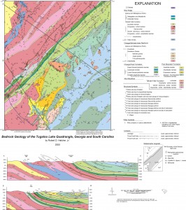
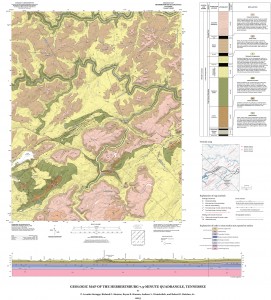
Our research activities are organized around a central idea: better understanding of the evolution of continental crust through the study of the structure of mountain chains. Permanent staff of the Tectonics and Structural Geology Research Group consists of myself; Nancy L. Meadows, who manages the office, helps with logistics (tracking vehicles, field activities, travel to meetings, etc.), and provides preliminary writing assistance and editing for all of us for theses, proposals, journal manuscripts, and books; and Andrew L. Wunderlich, a cartographer and GIS analyst (B.A., M.S., University of Tennessee), who is involved in conversion of the > 140 geologic maps my students and I have completed during the past 45+ years that remain in paper, stable base Mylar™, or digital Adobe Illustrator™ files to geodatabase formats compatible with ArcGIS™. He also assists students working on their mapping projects and cross sections, and assists me with digital graphics for map compilation projects, journal articles, and books.
Since the mid-00s we have used hand-held Trimble™ GeoXT 2005 Series GPS units, with data recorded in ArcPad™, which permit direct viewing and downloading of data into ArcMap™. Students have been very successfully using these instruments in the field, but they also carry a topographic map and field notebook for recording data in case of battery or instrument failure. We have recently begun to use iPads with the FieldMove™ app by Midland Valley that enables us to plot data in the field on a modern digital topo base and take photos and make notes that are linked to their stations. These data are then transferred to a computer and maps are compiled in ArcMap. A Brunton™ compass is still used to collect structural data, but the data are recorded in the iPad and a field notebook. We commonly lease vehicles from the University motor pool as needed. Generally, each group working in a field area will have a University vehicle assigned to it to minimize the need to use personal vehicles. Today, field projects are frequently supported by grants from the EDMAP component of the National Cooperative Geologic Mapping Program (administered by USGS), but in the past both students and my own field research have been supported by grants from the National Science Foundation, U.S. Department of Energy, and the Nuclear Regulatory Commission. These grants provide support primarily for field expenses and salary support for students.
We also have a Leitz Ortholux Pol™ microscope for thin section work, equipped with a digital camera, mechanical stage, and a Leitz universal stage. Our group has a cartographic laboratory equipped with three Dell™ and two Macintosh™ computers for cartographic, GIS, and other work. We generally have our thin sections prepared commercially. Whole-rock chemical analyses of major, minor, trace, and rare-earth elements are performed by a commercial laboratory.
The detailed geologic maps my students and I produce must be of the highest quality, produced with the same standards that would make them suitable for publication by a state geological survey or the U.S. Geological Survey. All of our EDMAP-supported geologic maps receive rigorous field review from state geological survey or U.S. Geological Survey geologists, as required by the program. Most of the geologic maps produced as products of support from other agencies are similarly reviewed. Additional reviews of geologic maps are acquired where we lead field trips for regional geological societies or the Geological Society of America. Numerous suggestions and alternatives are proposed for interpretation of the geology, with additional suggestions for revision of our maps. Another reason for the need to produce highest quality detailed geologic maps is that these data sets provide the basis for best interpretations of crustal structure and a context for petrographic, geochemical, and geochronologic work. Detailed geologic maps and related laboratory data also have provided numerous surprises that form a springboard to new ideas for interpretation of major structures, as well as grounds to question or abandon accepted hypotheses.
For the past several years, students working in the interior parts of the Appalachians have separated zircons from plutonic, metavolcanic, and metasedimentary rocks for analysis on the Stanford–USGS Sensitive High Resolution Ion Microprobe–Reverse Geometry (SHRIMP–RG) instrument in Menlo Park, California. Determination of crystallization ages of plutonic and volcanic rocks, ages of detrital zircons, and timing of metamorphism are our primary goals, which provide timing context to help sort out tectonic history. The most important results of this work have been the confirmation of the North American origin of several suspect terranes in the internal parts of the Appalachians, and the existence of the Cat Square terrane—a Siluro–Devonian assemblage in the Inner Piedmont of the Carolinas and Georgia. We have been fortunate enough to date to have travel funds for students to conduct their own analyses. Useful 87Sr/86Sr and εNd data have also been obtained through other laboratories.
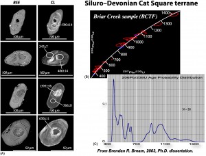
(A) Back-scattered (BSE) and cathodeluminescence (CL) images of zircons (with spot ages). (B) Concordia plot of the U-Pb ages of zircons identifying the mix of North American (± 1.0 billion years old) and Peri-Gondwanan (500 and 600 million years) ages. (C) Summed probability plot of the zircons from one of the samples that become part of Brendan Bream’s data that resulted in discovery of the Cat Square terrane in the Carolinas and Georgia Piedmont.
Current Research Projects
We have several current projects that have both focused and long-term goals. All are multidisciplinary, but are based on field geology and detailed geologic mapping.
This is the high-grade core of the part of the mountain chain that formed during the Devonian-Mississippian Acadian–Neoacadian orogeny, which was caused by A-subduction of already amalgamated crustal elements formed during the Taconian orogeny, and a remnant ocean, beneath the colliding Carolina superterrane. Several decades of field, geochronologic, structural, and petrologic work in the Carolinas and Georgia IP now permit us to make this generalized statement about its history, but there are still numerous unanswered questions. At least 10 M.S. student theses have been completed in the South Mountains (1998–2002), Brushy Mountains (2002–2007), and central IP in North Carolina (2006–2009), and several Ph.D. and M.S. theses have been completed in the IP and Pine Mountain window southeast of Atlanta. The work in the North Carolina IP has built an island of detailed knowledge of some 900 mi2, which is adjacent to other islands of detailed geologic mapping in the western IP and Sauratown Mountains window in western North Carolina and southward into South Carolina that extends into the Blue Ridge of the Carolinas and Georgia.
The project in the central Georgia IP south of Atlanta has recently been completed, with three M.S. and one Ph.D. students completing their research here. A Ph.D. student and I worked here during the early to mid-1980s, and we were drawn back into this area by analysis of U.S.G.S. regional aeromagnetic data that revealed several interesting features in the Inner Piedmont and Pine Mountain window. The recent project involved working out the timing and deformational history of a large fault identified in the aeromagnetic data, but had never been investigated in detail on the ground. The students who worked there recently have, with the assistance of some new SHRIMP ages, demonstrated that the boundary of interest is indeed the terrane boundary (Brindle Creek fault) that separates rocks of the western Inner Piedmont (eastern Tugaloo terrane) from the Cat Square terrane, first recognized in North Carolina. Detailed geologic mapping along the terrane boundary revealed that the Towaliga fault truncated the Brindle Creek and the southwest end of the Cat Square terrane. The major surprise that has occurred with this project is the discovery that the late Paleozoic dextral Towaliga fault was reactivated during the Mesozoic, again by sinistral strike slip motion producing mylonite composed almost entirely of quartz along some segments, but stepovers filled with quartz cataclasite along others. It has been known for a long time that the Towaliga was reactivated farther west along the northern boundary of the Pine Mountain window as a normal fault. Reactivation occurred about the same time as intrusion of the Central Atlantic Magmatic Province (CAMP) Mesozoic diabase dikes in the eastern US (~200 Ma). This surprise, coupled with existing data from other parts of the Blue Ridge and Piedmont, have provided new insight into the breakup of Pangea—telling us that the breakup was a much more complex process than has been previously thought.
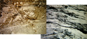
Photomicrograph of quartz breccia and mylonite.
[TECTONIC MAP GOES HERE]
Numerous problems remain in the IP in the Carolinas and Georgia that are worthy of being addressed.
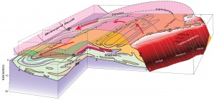
This project is also one of long-standing effort, which began during the late 1960s with my first NSF grant. We have mapped > 1680 mi2 of contiguous area from SE Tennessee into South Carolina to address the processes that formed the Blue Ridge, Brevard fault zone, and rocks of the Inner Piedmont immediately SE of the Brevard fault. Several recent M.S. and Ph.D. theses have addressed problems within this area, in addition to geologic mapping and structural, stratigraphic, and petrologic work that I have completed. We have documented the polyphase deformation and metamorphism, resolved stratigraphic relationships in amphibolite facies rocks, determined the ages of several plutons, and named several previously unknown tectonostratigraphic terranes and major rock units in this region. The Brevard fault is one of the most controversial faults in the world, yet is one of the most-studied faults in the Appalachians. Several decades of study of this fault suggest that it had a Devonian–Mississippian history of high-temperature dextral motion under plastic conditions followed by late Pennsylvanian–Early Permian lower temperature reactivation under plastic greenschist facies conditions, and then Permian reactivation as a thrust fault under brittle conditions. We also have spent a large amount of time working is smaller parts of this fault. One recent M.S. thesis dealt with determination of kinematic vorticity (Wm) and quartz microfabric relationships on samples collected in the best-exposed part of the Brevard fault zone mapped in detail earlier. A paper has recently been completed on the origin of two kinds of horses that occur in the Brevard fault zone: carbonate horses that likely are derived from footwall Valley and Ridge rocks that may occur beneath the Blue Ridge thrust sheet and were carried into the Brevard by the last (Permian) movement event, and crystalline rocks horses that were emplaced earlier, but, based on new geochronologic data, are composed of Carolina superterrane rocks. This led to the conclusion that Carolina at one time covered all of the Inner Piedmont and eastern Blue Ridge, permitting some of these rocks to be caught up in the Brevard fault zone as horses derived from above. Interesting problems remain that could be addressed in the future.
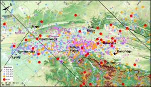
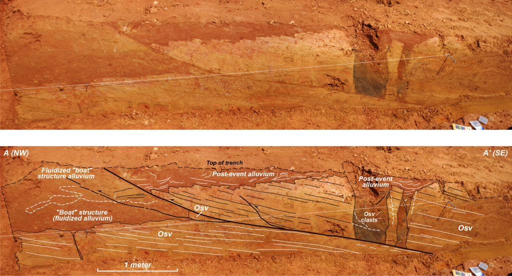
This is a Nuclear Regulatory Commission-supported project for which a one year pilot study was completed in 2010. Key questions being addressed are: (1) Has the ETSZ generated earthquakes larger than any in the historical record? (2) What are the largest earthquakes that can be generated in the ETSZ? and (3) How frequently do large earthquakes occur here? Identification of liquefaction features in the field, and then determination of the magnitude of the earthquake(s) that caused them will answer Question (1). Question (3) will be addressed, but the answer involves development of a large-earthquake chronology, again possibly a multi-year undertaking. Lack of liquefaction features where we have already identified liquefiable materials over wide areas in the ETSZ would be a very important result that that would have a direct bearing on all three questions. Nevertheless, we have discovered several thrust faults and a normal fault that involve Quaternary river sediments and bedrock. Movement on at least one of these faults has been dated at post-15,000 years.
The techniques being used are reconnaissance of aerial photos, and then field examination of banks of streams and reservoirs for evidence of earthquake-related liquefaction and deformation, including faulting. We have already found evidence of possible liquefaction features in floodplain deposits along several streams and rivers, and have previously observed small faults, folds, and other deformation features in Pleistocene to Holocene alluvial materials throughout the ETSZ. Where we have found deformation features that involve both bedrock and Quaternary sediments, we have conducted detailed studies frequently involving geologic mapping of small areas and detailed mapping of stream and man-made exposures of these features. We also have been conducting stream reconnaissance to search for deformation and liquefaction features. One University of Tennessee–Knoxville graduate student has completed their M.S. research on this project, and a Ph.D. research project is underway. At least one M.S. student is working on a related research project at the University of Memphis, which is one of the collaborators in this project.
The cross section extends from Atlantic Ocean crust off the coast of North Carolina to Pacific Ocean crust off the coast of California. This project has a two-fold intent, with one goal to produce a technical geologic-geophysical cross section down to 250 km in the mantle, and the other is have an artist take the technical cross section and produce a version suitable for use in junior high to senior high earth science classes, and introductory undergraduate college and university geology classes. This is a cooperative project between W. R. Muehlberger (lead scientist, University of Texas–Austin), Karl Karlstrom (University of New Mexico, lead scientist on the western half), Jason and Zorca Saleeby (Caltech), Rodger Denison (University of Texas–Dallas), Randy Keller (University of Oklahoma), and myself (lead scientist on the eastern half). We intend to publish the cross section in the next several years.
This is a cooperative project with the US Geological Survey that began in the 1970s, and has produced numerous papers and presentations at professional meetings. It involves several USGS geophysicists and geologists. We are currently finishing an interpretation of this region and are preparing at least one paper for publication.
This is a new project (introduced above) that will attempt to understand the distributions and relationships of Mesozoic small-displacement crustal faults to the breakup of Pangea and the opening of the Atlantic Ocean. The Triassic–Jurassic basins and diabase dikes and sills have been known for a long time. Brittle faults at high angles to the orientations of diabase dikes have also been known for several decades. These faults are now known to be more widely distributed than previously thought, and, where detailed mapping is available, can be shown to be interconnected. This project intends to attempt to resolve the kinematics and interrelationships among all of these Mesozoic structures.
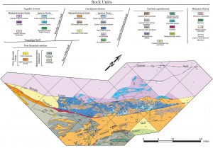
Detailed geologic map of the NE end of the Pine Mountain window in central Georgia. Mesozoic faults contain siliceous cataclasite pods, and trend both ~035 and ~070 throughout the study area. Note the widespread nature of ribbon quartz mylonite (white stars).
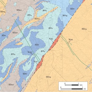
Detailed geologic map (without structural data; Huebner, unpublished) showing ~2.5 km of sinistral offset of diabase dikes (TRJdd) along the Towaliga fault zone near Stewart, GA. SDmg – metagraywacke; SDsch – schist; SDhf – High Falls granite; PPdp – Dows Pulpit granite; PPis – Indian Springs granite; TRJsc – siliceous cataclasite.
An M.S. student recently began detailed geologic mapping of an area in southeastern Tennessee with the goal of better understanding the processes related to emplacement of several large horses of Lower Cambrian rocks along the Great Smoky fault at the boundary between the Blue Ridge and Valley and Ridge. This work is supported by a grant from the EDMAP component of the National Cooperative Geologic Mapping Program (managed by the USGS).
